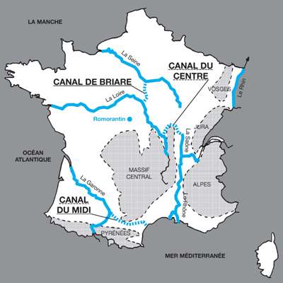
This is a basic but clear map indicating the extent to which the canal system interconnects different waterways and regions. I’ve recently started thinking about it, particularly the Midi Canal as Louis XIV was alive when this was being constructed and it has a remarkable story and linked the Mediterranean Sea with the Atlantique Ocean. To link two rivers, how was this topography achieved. How would this work for example, connecting the Loire and the Saone so near their source, or at any point? Could Paris once be reached by boat from the Loire? What is this waterway like today? Watch this space ..
Britannica have a long article on the history of waterways in Europe/France provided on the link at the end of this abridged article.
Canals (Britannica)
The 16th to 18th century
The development of the mitre lock, a double-leaf gate the closure of which formed an angle pointing upstream, heralded a period of extensive canal construction during the 16th and 17th centuries. The canals and canalized rivers of that period foreshadowed the European network to be developed over many years.
In France the Briare and Languedoc canals were built, the former linking the Loire and Seine and the latter, also known as the Canal du Midi, linking Toulouse with the Mediterranean. Both were remarkable feats of engineering. The Briare Canal (completed 1642) rose 128 feet to a plateau with a summit level 3.75 miles long and then dropped 266 feet to the Loing at Montargis. It included 40 locks, of which a unique feature was a staircase of six locks to cope with the fall of 65 feet on the descent from the Loing to Rogny. Construction of the 150-mile Canal du Midi joining the Bay of Biscay and the Mediterranean via the Garonne and the Aude ran through very rugged terrain. Begun in 1666 and finished in 1692, it rose 206 feet in 32 miles from the Garonne at Toulouse to the summit through 26 locks, and, after a three-mile stretch along the summit, then descended 620 feet through 74 locks for 115 miles. Near Béziers a staircase of eight locks was built, and six miles farther upstream a tunnel 180 yards long was constructed; three major aqueducts carried it over rivers, and numerous streams were diverted beneath it in culverts. The most notable technical achievement was a complex summit water supply that included unique diversion of flows and storage provision.
Midi Canal
By Michael Clarke
Midi Canal, also called Languedoc Canal, French Canal du Midi or Canal du Languedoc, historic canal in the Languedoc region of France, a major link in the inland waterway system from the Bay of Biscay of the Atlantic Ocean to the Mediterranean Sea. It was built in the 17th century at a time when France was the centre of civil engineering excellence. The Midi Canal connects Toulouse, using water from an artificial reservoir built in the Montagne Noire (Black Mountain), with the Mediterranean at Sète via the Étang de Thau (Thau Lagoon). canal in France. The Midi Canal was Europe’s first long-distance canal and was designated a UNESCO World Heritage site in 1996.
After Leonardo da Vinci designed the first mitre gates in Milan (1497), he was brought to France in 1516 by Francis I, king of France and Milan. Leonardo looked at proposals for canals from the Garonne River to the Aude River and from the Loire River to the Saône River. The second was considered too difficult, but as the Hers and Fresquel, tributaries of the Garonne and Aude rivers, have sources just a few miles apart, a canal between them was considered possible, though the lack of a local water supply for the summit frustrated engineers for the next century and a half.
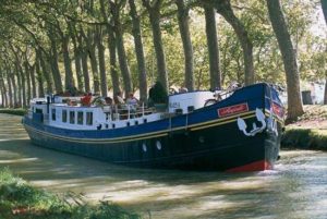
A tour boat on the Midi Canal, Languedoc region, France.C. Sappa—DeA Picture Library
The idea of a canal to link the Atlantic and Mediterranean was not abandoned, however. Pierre-Paul, Baron Riquet de Bonrepos, together with his engineer, François Andreossy, finally overcame the main design problem of providing a sufficient water supply system for the summit with plans for building a dam. Louis XIV granted permission for the construction of the canal in 1666, Riquet’s case having been supported by the finance minister, Jean-Baptiste Colbert. Work was soon under way on the water supply system, the most difficult part being construction of the Saint-Ferréol Dam. At the time, it was the greatest civil engineering work in Europe, holding back waters from the Montagne Noire, including the Laudot River, which could feed either the canal or the reservoir via two channels with a total length of 66 km (41 miles).
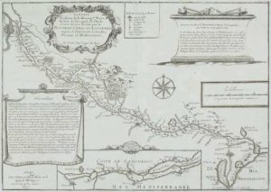
Seventeenth-century map showing the route and tributary waters of the “New Languedoc Canal,” or Midi Canal, France.© AbleStock.com /Jupiterimages
Despite political and financial pressure, Riquet pushed ahead with construction of the canal, though it affected his health. He died eight months before his canal opened in May 1681. In addition to some 100 locks, the project required building numerous bridges, an aqueduct, and the world’s first canal tunnel.
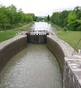
Midi Canal, Toulouse, France; constructed by Pierre-Paul, Baron Riquet de Bonrepos.Martin Pröfrock