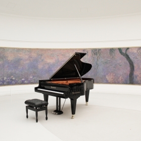
Musée de l’Orangerie
Jardin des Tuileries, Place de la Concorde, Saint-Germain-l’Auxerrois
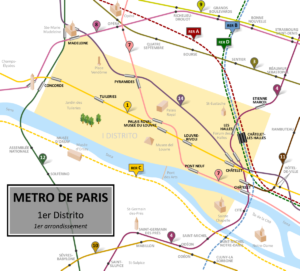
The 1st arrondissement of Paris is one of the 20 arrondissements (administrative districts) of the capital city of France. Situated principally on the right bank of the River Seine, it also includes the west end of the Île de la Cité. The arrondissement is one of the oldest in Paris, the Île de la Cité having been the heart of the city of Lutetia, conquered by the Romans in 52 BC, while some parts on the right bank (including Les Halles) date back to the early Middle Ages. It is the least populated of the city’s arrondissements and one of the smallest by area, a significant part of which is occupied by the Louvre Museum and the Tuileries Gardens. Much of the remainder of the arrondissement is dedicated to business and administration.
Quartiers
Each of the 20 Paris arrondissements is divided into four quarters (quartiers). The 1st Arrondissement is comprised of four quartiers as follows:
– Quartier Saint-Germain-l’Auxerrois
From Planet Bpm : The Saint-Germain-l’Auxerrois district is the heart of the French capital. It spreads from the western tip of Île de la Cité to the Jardin des Tuileries, the biggest, oldest garden in Paris. Fluctuat nec mergitur. (“She is battered by the waves, but does not sink”) was the motto of the boatmen’s guild which had its headquarters here during the reign of Hugh Capet, and the phrase subsequently became the city’s own motto.
Saint-Germain-l’Auxerrois surrounds the Louvre, whose buildings house a significant portion of French history. Originally built around 1190 by Philip II, ‘Augustus’, as a fortress to contain royal treasure before the monarch left to join the Crusades, the Louvre is now devoted entirely to culture, displaying Western art from the Middle Ages to 1848, treasures of Antiquity and, since 2005, Islamic art. The Church of Saint-Germain-l’Auxerrois, after which the district is named, adjoins the Louvre and can be visited outside service times.  The grounds of the Jardin des Tuileries host three major Paris museums: the Musée de l’Orangerie, devoted to Monet’s Nymphéas and the Jean Walter and Paul Guillaume collections, the Musée du Jeu de Paume, which exhibits contemporary art and photography, and the Musée des Arts Décoratifs with its significant fashion and textiles collection as well as a more recent section devoted to advertising.
Île de la Cité in the eastern part of the district also has some emblematic historical buildings such as the Conciergerie, the first royal residence in the city and later a forbidding prison under the Terror. It is a stone’s throw from Sainte-Chapelle, a masterpiece of the Gothic style with richly hued stained glass windows built by St Louis within the Palais de la Cité, now the Palais de Justice law courts.
– Quartier Les Halles
History


The wholesale market
Les Halles was the traditional central market of Paris. In 1183, King Philippe II Auguste enlarged the marketplace in Paris and built a shelter for the merchants, who came from all over to sell their wares. The church of Saint-Eustache was constructed in the 16th century. The circular Halle aux Blés (Corn Exchange), designed by Nicolas Le Camus de Mézières, was built between 1763 and 1769 at the west end of Les Halles. Its circular central court was later covered with a dome, and it was converted into the Bourse de Commerce in 1889.[6] In the 1850s, Victor Baltard designed the famous glass and iron buildings, Les Halles, which would last until the 1970s. Les Halles was known as the “Belly of Paris”, as it was called by Émile Zola in his novel Le Ventre de Paris, which is set in the busy marketplace of the 19th century.
Major conversion

Unable to compete in the new market economy and in need of massive repairs, the colourful ambience once associated with the bustling area of merchant stalls disappeared in 1971, when Les Halles was dismantled; the wholesale market was relocated to the suburb of Rungis. Two of the glass and cast iron market pavilions were dismantled and re-erected elsewhere; one in the Paris suburb of Nogent-sur-Marne, the other in Yokohama, Japan.[6]
The site was to become the point of convergence of the RER, a network of new express underground lines which was completed in the 1960s. Three lines leading out of the city to the south, east and west were to be extended and connected in a new underground station. For several years, the site of the markets was an enormous open pit, nicknamed “le trou des Halles” (trou = hole), regarded as an eyesore at the foot of the historic church of Saint-Eustache. Construction was completed in 1977 on Châtelet-Les-Halles, Paris’s new urban railway hub. The Forum des Halles, a partially underground multiple story commercial and shopping center, opened at the east end of the site in 1979 and remains there today. A public garden covering four hectares opened in 1986.[6] Many of the surrounding streets were pedestrianized.
Paris Les Halles: an urban transit hub to redevelop

Gare de Châtelet – Les Halles is Paris’s most used rail station, serving 750,000 travelers on an average weekday. The buildings and their surroundings have been criticized for their design. In 2002 Mayor Bertrand Delanoë announced that the City of Paris would begin public consultations regarding the remodeling of the area, calling Les Halles “a soulless, architecturally bombastic concrete jungle”.[7][8]
A design competition for the Forum and gardens was held, with entries from Jean Nouvel, Winy Maas, David Mangin, and Rem Koolhaas. Mangin’s design for the gardens, which proposed replacing the landscaped mounds and paths of the 1980s design with a simplified pattern of east-west pedestrian promenades and a large central lawn, was selected. The plan also includes extending the pedestrianized area further east to include all the streets bordering the gardens. Another competition was held for the redesign of the Forum. Ten teams submitted plans, and the proposal by Patrick Berger and Jacques Anziutti was selected in 2007. Their design includes a large undulating glass canopy which will cover the redesigned Forum.[8] STIF and RATP began plans for the remodeling of the Châtelet-Les-Halles station in 2007, and the following year Berger and Anziutti were awarded a contract for redesign of the station.
The station redesign includes new entrances on Rue Berger, Rue Rambuteau, and Place Marguerite de Navarre, an expanded RER concourse, and improved pedestrian circulation. Construction began in 2010 on a project which includes the gardens, Forum, and station, and is scheduled to continue through 2016. The clients are the City of Paris, RATP, which operates the Paris Metro, and La Société Civile du Forum des Halles de Paris, which operates the Forum.[6]
In film
Part of the actual demolition of the site is featured in the 1974 film Touche pas à la femme blanche (Don’t Touch the White Woman!), which iconoclastically restages General Custer‘s ‘last stand’ in a distinctly French context in and around the area.
In 1977, Roberto Rossellini made a 54-minute documentary film that testified to the public’s response to the demolition of Les Halles and the construction of Centre Georges Pompidou. “The result was a sceptical vision rather than a pure celebration.”[9]
The open-air market and Baltard’s pavilions were digitally reconstructed for the 2004 film Un long dimanche de fiançailles (A Very Long Engagement), which was set after the First World War.
- Les Halles, the new heart of Paris Les Halles, the new heart of Paris
- Des Racines des Alles: “Le nouveau coeur de Paris”, 12 March 2015
- Paris-Les Halles Les Halles redevelopment project
- Laure-Emmanuelle HUSSON, Le top 10 des centres commerciaux en France, Challenges, 13 mars 2014
- Plate from Baltard, Victor; Callet, Félix (1863), Monographie des Halles centrales de Paris, construites sous le règne de Napoléon III et sous l’administration de M. le Baron Haussmann, sénateur, préfet du département de la Seine [Monograph on the central Halles of Paris, constructed under the reign of Napoleon III and under the administration of Baron Haussmann, senator, prefect of the Seine Department] (in French), Paris: A. Morel
- Parimage, “Les Halles, The New Heart of Paris”. Mairie de Paris and SemPariSeine, July 2012.
- Rose, Michel (July 27, 2010). “Revamp of the Belly of Paris meets resistance – Reuters, July 27, 2010”. Uk.reuters.com. Retrieved 2012-01-26.
- Riding, Alan. “For Paris, the Newest Look Is a Canopy”. New York Times, July 7, 2007. Accessed December 25, 2012 [1]
- “Roberto Rossellini. Filming Beaubourg”. Retrieved 14 November 2015.
– Quartier Palais-Royal (Royal Palace District)
Formed for the first time at the time of the French Revolution , the district of Palais-Royal was formed of four districts :
- the district of Saint-Honoré Church ;
- the district of Saint-Roch church ;
- the district of the Jacobin church , rue Saint-Honoré ;
- the district of the Saint-Philippe-du-Roule church .
In 1790 this district takes the revolutionary name of section of the Mountain .
By prefectural decree of , the section of the Mountain, now section of the Butte-des-Moulins , which was located in the former 2nd arrondissement of Paris takes the name of district of the Palais Royal .
Its limits are then:
-
- Starting from Place Vendôme and following the streets of Neuve-des-Petits-Champs , Neuve-des-Bons-Enfants and Saint-Honoré to Place Vendôme.
The law of June 16, 1859 assigns this administrative district to the 1st arrondissement , with the following limits:
-
- A line starting from the rue de Rivoli, and following the axis of the streets of Dauphin and Neuve-Saint-Roch, Neuve-des-Petits-Champs, the Place des Victoires, the streets of Croix-des-Petits-Champs, Marengo, and Rivoli to the point of departure.
Situation and limits

The district of the Palais-Royal is formed of a rectangle, limited to the West by the street Saint-Roch, to the East by the streets of Marengo and Croix-des-Petits-Champs, to the North by the street of Little Champs, and to the South by the Rue de Rivoli.
In the heart of the 1st district, the district is between the neighborhoods of Place-Vendôme in the West, Les Halles in the East, Saint-Germain-l’Auxerrois in the South, Vivienne, in the 2nd district, in the North.
The two main North-South axes are Rue de Richelieu in the west of the Jardin du Palais Royal and Rue Croix-des-Petits-Champs in the East. The garden being crossed by no way, besides the lanes that limit it, only rue Saint-Honoré crosses the neighborhood from side to side in the east-west direction. The Haussmannian breakthrough that is the Avenue de l’Opera cuts the grid drawn in the seventeenth century oblique. The rue Coquillière, which connects the district Les Halles was pierced in the twelfth century at the time of the construction of the enclosure of Philippe Auguste; it is the oldest way of the district.
Main buildings
The district is organized around the eponymous Royal Palace and its garden , open to the public.
Administration
- Ministry of Culture
- Constitutional Council
- Board of state
- Dispute Tribunal
- Bank of France
- Portes Saint-Honoré (successively destroyed)
Private Hotels
- Palais Royal
- Hotel Bauyn de Péreuse
- Hotel Bergeret de Grancourt
- Hotel Bergeret de Talmont
- Charlemagne Hotel
- Montplanque Hotel
- Hotel de Soyecourt
- Toulouse Hotel
- Chancery of Orleans (demolished)
Religious life
Tourism
Theaters
Library
Cafes, restaurants, cabarets, bars
- Grand Véfour
- Takara
- Milord the Arsouille (closed)
- The Ringside (closed)
- Café de Foy (closed)
- Coffee of the Regency (closed)
- Café des Blinds (closed)
- Café Lamblin (closed)
Closed house (closed)
Covered passageways
Along the Garden of the Palais-Royal
Clockwise:
- Montpensier Gallery
- Beaujolais Gallery
- Valois Gallery
- Garden Gallery , Gallery of Orleans and Gallery of Cour-d’Honneur , parallel, all three between the garden and the main courtyard.
Access to the Palais Royal Garden
Clockwise:
- Gallery of Chartres
- Passage of Montpensier
- Passage of the Perron
- Passage of Valois
- Passage of the Cour-des-Fontaines
- Proues Gallery
Second crown around the Jardin du Palais-Royal
Clockwise:
Fountains
Public art
- Equestrian statue of Joan of Arc (Pyramids Square)
- Equestrian statue of Louis XIV (Place des Victoires)
- The Two Plateaux , commonly called The Buren Columns
- The Nightclub Kiosk
In the subway :
-
- The thought and the soul huicholes (station Royal Palace – Louvre Museum )
- PILI ( Pyramids station)
- Tissuration n ° 14 ( Pyramides station)
Famous businesses
- Fauré Le Page (closed), on the site of the Art Nouveau building at the corner of the streets of Richelieu and Montpensier.
- Louvre department stores (closed), now the Louvre des antiquaires
- House Bacqueville
- Kitsuné House
– Quartier Place Vendôme.
The section of the Place Vendôme was created in 1790, administrative district which became in 1792 the section of the Spades then in 1795 the area of the Place-Vendôme, located then in the 1st district of Paris whose limits started from the place Vendôme and following on the left, the streets of Neuve-des-Petits-Champs, Louis-le-Grand, Chaussée-d’Antin, Saint-Lazare, Arcade, Madeleine, Faubourg-Saint-Honoré and Saint-Honoré. ‘in the Place Vendôme 1 .
A new administrative district is created by the imperial decree of November 1 , 1859, whose annexed map defines the district as: “[Quartier] Place Vendome [sic] . A line starting from the rue de Rivoli and following the axis of the streets of [sic] Saint-Florentin, Richepance and Duphot. New-Capucines streets, Neuve-des-Petits-Champs. Neuve-Saint-Roch, of the Dauphin. And from Rivoli to the point of departure 2 .“