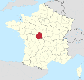
Indre is a department in the centre of France named after the river Indre. The inhabitants of the department are called Indriens. Indre is part of the current region of Centre-Val de Loire and is surrounded by the departments of Indre-et-Loire, Loir-et-Cher, Cher, Creuse, Vienne, and Haute-Vienne. The préfecture (capital) is Châteauroux and there are three subpréfectures at Le Blanc, La Châtre and Issoudun.
History
Indre is one of the original 83 departments created during the French Revolution on 4 March 1790, by order of the National Constituent Assembly. The new departments were to be uniformly administered and approximately equal in size and population to one another. The department was created from part of the former province of Berry.
Before the Roman conquest, the Celtic Bituriges tribe occupied an area that included Indre, Cher, and part of Limousin. Their capital was Avaricum (Bourges), and another important settlement was at Argenton-sur-Creuse. The area then became part of Roman Gaul after its conquest by Julius Caesar around 58 BC, and enjoyed a period of stability. Following the collapse of the Roman Empire in the West, the Frankish tribes living in Gaul were united under the Merovingians, and succeeded in conquering most of the country in the sixth century AD. From this time, the Franks controlled most of Gaul and the Carolingian Empire was the last stage of their rule. The Carolingian dynasty reached its peak with the crowning of Charlemagne and after his death in 814, it began to fragment. The Carolingian territories were divided into three sections in 843 at the Treaty of Verdun, and the area that is now the department of Indre, became part of West Francia. In 869, the king of Middle Francia died without leaving a legitimate heir, and eventually part of that kingdom was added to West Francia to effectively form the medieval Kingdom of France.
A castle was built at Châteauroux in the late tenth century. In the eleventh century, the lords of Châteauroux were powerful in the region; their “principality” covered two thirds of the current Department of Indre and they had their own coinage.
The 4 arrondissements of the Indre department are:
- Arrondissement of Le Blanc, (subprefecture: Le Blanc) with 56 communes. The population of the arrondissement was 32,168 in 2013.
- Arrondissement of Châteauroux, (prefecture of the Indre department: Châteauroux) with 80 communes. The population of the arrondissement was 127,499 in 2013.
- Arrondissement of La Châtre, (subprefecture: La Châtre) with 58 communes. The population of the arrondissement was 33,172 in 2013.
- Arrondissement of Issoudun, (subprefecture: Issoudun) with 49 communes. The population of the arrondissement was 35,252 in 2013.
Geography
Indre is a department in central France and is part of the region of Centre-Val de Loire. The capital and largest town in the department is Châteauroux. To the north of Indre lies Loir-et-Cher, to the east Cher, to the south lies Creuse and Haute-Vienne, to the southwest lies Vienne, and to the northwest lies Indre-et-Loire. Most of the department is relatively level plains in the broad Loire Valley.
The area of the department is 5,880 km2 (2,270 sq mi) and it is some 100 km (62 mi) from north to south and some 90 km (56 mi) wide. The land is undulating and slopes gently towards the northwest. The main rivers are the Creuse, the Claise and the Indre. The Creuse, a tributary of the Vienne, is 264 kilometres (164 mi) long and has been impounded in several places; at the time it was built in 1926, the Eguzon Dam was the largest dam in Europe.The Claise is 88 kilometres (55 mi) long and is a tributary of the Creuse. The Indre is a longer waterway and flows centrally through the department from south to north, through the major towns of La Châtre, Châteauroux and Loches. It is a tributary of the Loire, joining it at Chinon in the neighbouring department of Loir-et-Cher.
Indre is divided into four natural regions; North Boischaut is undulating land with an altitude between 80 and 215 m (260 and 710 ft) and occupies the northeast of the department, South Boischaut is hilly and lies in the south and southeast, a marshy tract of land known as Brenne is in the southwestern part of the department, and the flat, dry, flinty limestone plateau of Champagne berrichonne is in the east and continues into Cher. The highest point of the department is near the town of Pouligny-Notre-Dame where the land rises to 459 m (1,506 ft) above sea level.The department is made up of 680,910 ha (1,682,600 acres) of land of which 401,535 ha (992,210 acres) are under arable cropping, 85,305 ha (210,790 acres) are grassland, 67,423 ha (166,610 acres) are woodland, 18,110 ha (44,800 acres) are under grapes and 18,273 ha (45,150 acres) are gardens and orchards. The remaining land is heathland, urban land and waterways.
The economy is mostly agricultural. In the past many sheep were raised in the department and woollen yarn was the main manufactured product. There is also a linen industry as well as the manufacture of hosiery and paper. The department has some minerals in the form of coal, iron, stone, marble and clay.