CLICK Refresh FOR SLIDES
Google Maps – Chateau de Montsoreau and Museum of Contemporary Art
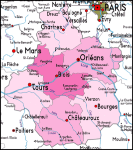
 Lying to the southwest of Paris, the Centre region takes in the most visited part of the Loire valley, and areas to the north and to the south. As well as the most popular of the Loire valley chateaux, it also includes the forests of the Sologne, south of the Loire, and the gentle hills and valleys of the Berry region, to the south.

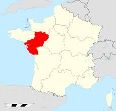
The Pays de la Loire region is a recent creation, not one of France’s historic regions. Indeed, the regional capital, Nantes, was once the capital of Brittany – to which it no longer belongs. In historic terms, Pays de la Loire covers parts of the old provinces of Brittany, Anjou, Maine and Poitou. The Pays de la Loire covers the area to the south of Brittany and Normandy, along the lower stretches of the river Loire, the longest river in France.
The region is composed of five departments, two of them coastal – the Loire Atlantique (44) and the Vendée (85) – and three of them inland, the Mayenne (53), the Sarthe (72) and the Maine et Loire (49).
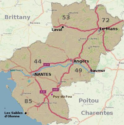
Nantes (44), the regional capital is the sixth largest city in France, with 270,000 inhabitants in the urban borough of Nantes, and an estimated 800,000 inhabitants in the urban area as of 2008. It is located on the Loire, 50 km inland, and is the largest economic hub in the north west of France. In the eighteenth century, Nantes (like Bristol) was a flourishing seaport, indeed the most important seaport in France; the city acquired great wealth at that time, wealth which is reflected to this day in its urban heritage. Today, most of the shipping activity has moved to the mouth of the Loire, to the port of Saint Nazaire, which is also one of the major ship-building cities in Europe. It was in the Saint Nazaire dockyards that the new flagship of the Cunard line, the world’s largest passenger ship, the Queen Mary 2, was built. A clear birds-eye view of the shipyards can be had from the Pont de Saint Nazaire, the high road bridge that spans the Loire estuary. (Originally a toll bridge, this bridge is now free to cross).
On the coast of the Loire Atlantique department lie two of France’s historic seaside resorts, La Baule and Le Croisic. The area round Le Croisic is also famous for its salt pans, and “sel de Guérande” is one of the best-known types of salt in France. The town of Guérande is a delightful small ancient walled city, just inland from the salt marshes.
South of the Loire Atlantique department lies an area known as Vendée. The modern department (85) is much smaller than the historic area that once carried this name. Vendée is famous in the history of France as one of the old bastions of Protestantism; after the revocation of the Edict of Nantes in 1685, and the end of religious tolerance, tens of thousands of Vendéen protestants fled from this part of France, and went to live in England, or America. Thus many people in England can trace some of their ancestry back to this part of France.
After the French Revolution, Vendée was a centre for the royalist counter-revolution.
The department is largely flat in the northern coastal area, low-lying and gently undulating inland. The capital, the city of La Roche sur Yon, is a small rural city in the middle of the department. The coast is built up round the seaside resorts, notably the fine beaches at les Sables d’Olonne, Saint Gilles Croix-de-Vie and St. Jean de Monts, but elsewhere there are stretches of empty coastline. In parts, a band of pine forests, planted on land that was once sand dunes, protects the flat farmland behind from the Atlantic winds and the sand – and protects it against flooding when Atlantic storms batter the coastline.
Further inland, the department of Maine et Loire (49) covers a territory to the north and south of the Loire.This is the heart of the region known as Anjou, and its capital Angers is one of the great historic cities in the Loire valley. Anjou was the fief of the Angevins, better known as the Plantagenets, who, starting with Henry II, ruled England for three centuries. The great castle of the counts of Anjou, in Angers, is one of the biggest medieval fortresses in Europe. Henry II, his wife Eleanor of Aquitaine, and their son Richard the Lionheart are buried at the Abbey of Fontevraud, between Saumur and Chinon.
The two remaining departments of this region, Sarthe (72) and Mayenne (53) form the rest of the old provinces of Anjou and Maine, and border on Normandy. Rural departments, and strongly agricultural, they both have more in common with Normandy than they do with Vendée. Half the population of the department of the Sarthe lives in the urban area round the capital, Le Mans, famous for its annual motor race. Apart from that, the Sarthe is deeply rural. La Flèche, an attractive small town on the river Loir (without an -e !) boasts one of the best and oldest zoos in France, coverning some 30 acres. Laval, capital of the Mayenne, is a small city with a historic centre. The city is located on the banks of the river Mayenne, which crosses the department from north to south, a navigable waterway with opportunities for boat hire, and 85 km of towpath idel for cyclists and hikers. The department of the Mayenne also boasts the highest point in the northwest quarter of France, the summit of the Mont des Avaloirs, at 417 metres, about 1350 ft.
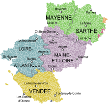
Map of the Pays de la Loire with its five departments
showing the provinces that existed on its territory in the XVIII century.

Administrative Regions
For detail see about-france.com
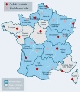
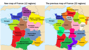
Since 2016, Metropolitan France has been divided administratively into 13 regions; until the end of 2015, there were 22 regions.
The reduction has been obtained by merging certain regions together, as can be seen on the map above. Some of the new super-regions combine the names of the old regions, others like Occitanie or Grand Est are new. Meanwhile the old regions that have been merged are likely to keep their identities, though not their institutions, for some time to come, specially those that like Limousin, Champagne or Alsace, which are historic provinces or areas of France.
There are also five overseas regions.
Regions have extensive powers in the fields of transport, infrastructure, economic development, tourism and education (provision of lycées), and since these powers were devolved to them from 1981 onwards, regions have often worked hard over the years to develop a regional identity.
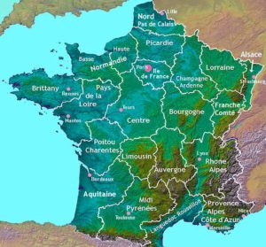
Many of today’s French regions correspond largely to the provinces of pre-revolutionary France, and share the same name. Others are modern creations including areas from different historic provinces.
France also has a number of well-known “areas” which are not administrative regions. These are historic or geographic areas, or simply areas that have an identity in terms of tourism.
Terrain
Historical / Tourist Regions
CLICK Refresh FOR SLIDES
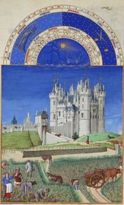
Chateau de Saumur – as pictured in Les Très Riches Heures du duc de Berry in 1410.
Saumur is a town in the Maine-et-Loire département, which is within the Pays de la Loire région in North-Western France on the Loire River. It is known for its cavalry school and for its wines. The town, dominated by the château of the dukes of Anjou, is located on rising ground between the Loire River and its tributary the Thouet, 3 km from their confluence.
Early settlement of the region goes back many thousands of years. Located on the south of the town is France’s largest neolithic megalith. The Dolmen de Bagneux is 23 meters long and built from 15 large slabs of the local stone weighs over 500 tons.
Prior to the French Revolution Saumur was the capital of the Sénéchaussée de Saumur, a bailiwick, which existed until 1793. Saumur was then the location of the Battle of Saumur during the Revolt in the Vendée, becoming a state prison under Napoleon Bonaparte. The town was an equestrian centre with both the military cavalry school from 1783 and later the Cadre Noir based there.
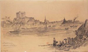
The Château de Saumur was constructed in the 10th century to protect the Loire river crossing from Norman attacks after the settlement of Saumur was sacked in 845. The castle, destroyed in 1067 and inherited by the House of Plantagenet, was rebuilt by Henry II of England in the later 12th century. It changed hands several times between Anjou and France until 1589.
The town’s industries include the processing of the traditional agricultural products of the region (wines, mushrooms, and vegetables), aluminum fabrication, and plastics manufacture. Saumur is also an administrative and service centre. Pop. (1999) 29,857; (2014 est.) 27,301.
CLICK Refresh FOR SLIDES
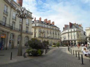
Before my arrival in Nantes, France I was surprised by the nod of approval given by French people in Australia. It has a population of 200,000 people making it lively while retaining a beautiful sense of space and though one of my earliest experiences of small French cities, I expect Nantes to remain as my benchmark for assessing the quality of life in all other places.
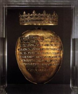
History (Britannica)
Nantes, city, Loire-Atlantique département, Pays de la Loire région, western France. Nantes is situated at the head of the estuary of the Loire River, where it is joined by the Erdre and the Sèvre rivers, 35 miles (56 km) from the sea and southwest of Paris. It is one of the French towns that has changed the most in the 20th and 21st centuries.
Nantes derives its name from the Namnètes, a Gallic tribe who made it their capital. It became a commercial centre under the Romans. The Normans, after pillaging the town, occupied it from 834 to 936. After a long struggle in the Middle Ages between the counts of Nantes and Rennes for the sovereignty of Brittany, in 1560, Francis II, king of France (1559–60), granted Nantes a communal constitution. During the Wars of Religion (1562–98), Nantes joined the Catholic League and only opened its gates to Henry IV, king of France (1589–1610), in 1598, the same year he signed the Edict of Nantes, a charter assuring religious and civil liberties to the Protestants. During the French Revolution, Nantes suffered the ruthless repression of an envoy of the revolutionary Committee of Public Safety named Jean-Baptiste Carrier. In 1793 Carrier replaced executions by the guillotine, which he considered too slow, with mass drownings. The city was occupied by the Germans during World War II.
Greatly modified by an urban renewal plan that was adopted in 1920, Nantes was further altered and extended after having been partly destroyed in World War II. In the 1960s Nantes was designated as one of the eight provincial counterweights to reduce the dominance of Paris on French national life. It has become a dynamic regional centre, with a diversified economic structure. Traditional industries such as food processing, engineering, and the manufacture of components for the aeronautical industry remain important, but recent growth has occurred in fields such as biotechnology. A large scientific park, created in 1987, was designed to foster these activities. Nantes is also a major business centre and is the home of many regional headquarters of both industrial and services firms. A number of public and private sector offices have relocated from Paris to the city. Nantes has a large higher education section. The original university (founded 1460) was abolished during the French Revolution, but a new one was established in 1961. Tourism has been stimulated by redevelopment of part of the former docklands and the building of specialized conference facilities.
CLICK Refresh FOR SLIDES
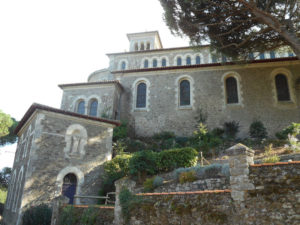
Clisson is a commune in the Loire-Atlantique département in Pays de la Loire in western France. It is situated at the confluence of the Sèvre Nantaise and the Moine 27 km southeast of Nantes by rail. The town and the celebrated family of Clisson, the most famous members being Olivier IV de Clisson and Jeanne de Clisson, take their name from the stronghold, its imposing ruins in part dating from the thirteenth century. Within then independent Brittany, Château de Clisson, situated at a crossroads for Anjou and Poitou, was one of the great fortified places on the frontiers of the Duchy of Brittany. The first Lords of Clisson occupied the site from the 11th century. They are mentioned for the first time in 1040. Clisson was then the seat of a powerful châtellenie covering 23 parishes.
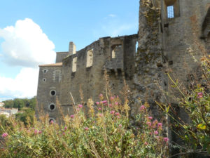
The castle
Most of the present castle was built in the 13th century. Constructed by Guillaume de Clisson, on a rocky outcrop dominating the Sèvre Nantaise, its form at that time was an irregular polygon flanked by round towers and isolated from the rocky plateau by a shallow moat. In the 14th century, Olivier III de Clisson incorporated the gatehouse into a massive quadrilangular keep. The two semicircular towers of the gatehouse collapsed in the 17th century. The castle became the setting for the turbulent lives of Olivier IV de Clisson and Olivier V de Clisson, named Constable of France in succession to Du Guesclin in 1380. The castle is said to be haunted by Jeanne de Clisson wife of Olivier IV.
In the 15th century, the fortifications were modernised to permit the use of artillery. In the second half of the century, the former entrance was modified and the curtain wall was extended and completed by a barbican. At the same time, the castle was enlarged to the west with a new rectangular enclosure nearly 100 m long, armed with towers with artillery casemates.
After 1420, the castle became the property of the Duke of Brittany. It was one of the favourite residences of Duke Francis II who was remarried there, to Marguerite de Foix in 1474. He built a second rectangular enceinte flanked by artillery towers. Around 1590, the troubled period of the French Wars of Religion necessitated the construction of three terraced bastions on the south. Thus, three lines of defence in depth protected the site.
Until the 17th century, the castle was the residence of the Avaugour family, descendants of François Ier d’Avaugour, illegitimate son of François II. He modified and transformed the castle to suit the tastes and fashions of the day. During the War in the Vendée, the town and its castle were burned by the Infernal columns of Jean-Baptiste Kléber. In 1807, the estate was bought by the sculptor François-Frédéric Lemot with the goal of conservation. During the 19th century, the ruined castle attracted Romantic painters and sculptors.
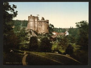
The castle ruins (seen here in the 1890s) were a source of inspiration for Romantic artists.
The remains of the castle were classed as a monument historique by a French Ministry of Culture decree of 13 August 1924. In 1962, the castle was sold by the Lemot family to the Conseil général of the Loire-Atlantique, who carried out important restoration works with the assistance of the French Ministry of Culture.
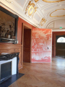
Permanent exhibition space at the estate
The influence of François-Frédéric Lemot is outstanding as he brought his taste for Italian art and architecture to Clisson.
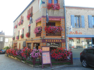
Today Clisson exists as a flavour of Italy within France’s North West and the building styles and materials attest to this. Red terracotta roof tiles mix with slate and the rectangular tower of l’Eglise Notre-Dame de Clisson sits atop the building as it cascades down the slope to the narrow roadways leading to the river. Bright geraniums and pizza restaurants make for great outdoor the market in Summer.
CLICK Refresh FOR SLIDES
Today Clisson exists as a flavour of Italy within France’s North West and the building styles and materials attest to this. Red terracotta roof tiles mix with slate and the rectangular tower of l’Eglise Notre-Dame de Clisson sits atop the building as it cascades down the slope to the narrow roadways leading to the river. Bright geraniums and pizza restaurants make for great outdoor the market in Summer. The influence of François-Frédéric Lemot is outstanding as he brought his taste for Italian art and architecture to Clisson.